The desert southwest is one of our favorite areas to explore. A huge percentage of the land is some form of federal land, whether National Park, National Forest, Bureau of Land Management or some other designation. Nonetheless, it's all beautiful. It's also very budget friendly as you can camp for free almost anywhere, except for a National Park! We've been through this area several times before, and while we hit some of our favorite stops, our goal this time was to explore some of the roads less travelled and some of the more remote areas. In the process, we also got to have a little fun driving our EarthRoamer, a.k.a. STEV, off the road, up and down mountains, and across creeks. This post is very picture heavy, both because it's been some time since our last update, and because we find the scenery so amazing.
 |
| After doing some mountain biking in Fruita, Colorado, we headed to the Colorado National Monument near Grand Junction, Colorado. |
 |
| The view from our campsite in the Saddlehorn Campground of the Colorado National Monument. The monument with spectacular canyons cut deep into sandstone is an area of desert land high on the Colorado Plateau, with pinion and juniper forests blanketing the plateau. |
 |
| Todd and Chip posing for a picture at the edge of the cliff near our campsite in the Colorado National Monument. |
 |
| A group of Big Horn Sheep pose for photos on the road leaving the Colorado National Monument in Colorado. |
 |
| Our dispersed camping site in the desert just north of Moab, Utah. Moab attracts a large number of tourists every year, mostly visitors to the nearby Arches and Canyonlands National Parks. The town is also a popular base for mountain bikers who ride the extensive network of biking trails and for off-roaders who come for the annual Moab Jeep Safari. |
 |
| Monitor and Merrimac buttes are two neighboring formations sitting at the edge of a plateau, overlooking Sevenmile Canyon, which is northwest of Moab and were a short biking distance from our campsite. |
 |
| Early one morning near our campsite, we watched this balloon inflate and gently float overhead. |
 |
| Chip and Todd, both in their hiking boots, exploring the area around our dispersed campsite near Moab, Utah. Many desert plants have thorns or prickers that aren't so kind to a puppy's paws. Chip quickly adapted to adorning the boots (which are really intended for use in the snow, but worked well in the sand), probably because he grew tired of getting the prickers stuck in his pads. |
 |
| Todd and Chip biking the "Slickrock Trail" in Moab, Utah. The Slickrock Trail is a popular mountain biking destination with worldwide fame. This 13-mile (20.9 km) loop takes intrepid riders over a landscape of "petrified" sand dunes and the eroded remnants of ancient sea beds. The Slickrock Trail is one of the more difficult rides in the Moab area, both technically and cardiovascularly. |
 |
| Todd, Chip and Shonah posing for a selfie on part of the Slickrock Trail overlooking the Colorado River in Moab, Utah. This was one of many trails we enjoyed while in the area that is a Mecca for mountain bikers. |
 |
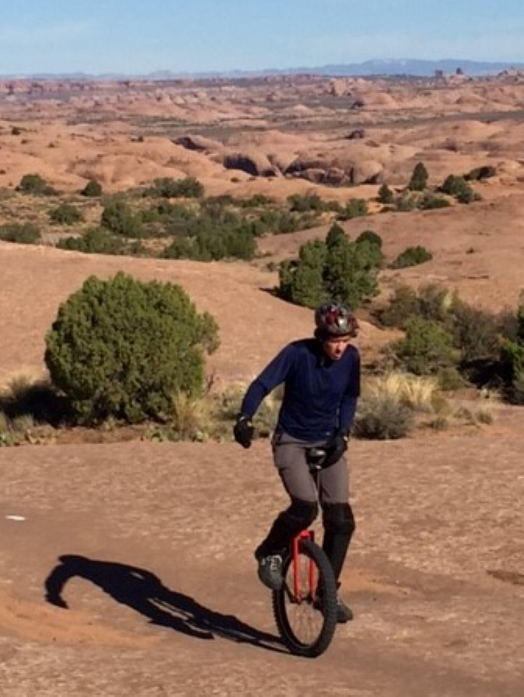
| As we were standing, fairly exhausted, at the end of our several hour ride up and down the Slickrock Trail, we saw this guy on a unicycle coming in behind us. Talk about making us feel like wimps for having two wheels. |
 |
| Shonah, Chip and Todd executing a jumping picture in the Slickrock campground high above Moab, Utah. |
 |
| Chip and Todd enjoying a hike in Arches National Park, Utah. |
 |
| Interesting rock formations in the Fiery Furnace in Arches National Park near Moab, Utah. |
 |
| Juniper trees in the desert have fascinating trunks. These trees are also self-pruning and in times of severe drought, can cut off water supply to one portion of the tree to preserve the rest. |
 |
| Landscape Arch in Arches National Park, Utah. |
 |
| Double O Arch in Arches National Park, Utah. |
 |
| Skull Arch in Arches National Park, Utah. Hint: Stand on your head and look at the arch. Then you will notice the skull shape. |
 |
| Delicate Arch in Arches National Park, Utah. |
 |
| Views from the Island in the Sky portion of Canyonlands National Park in Utah. The Island in the Sky as it's called, is a broad mesa wedged between the Green and Colorado Rivers. |
 |
| The views from the Island in the Sky stretch across canyon after canyon for more than 100 miles in the distance. |
 |
| The White Rim of the Island in the Sky is a nearly continuous sandstone bench 1,200 feet below the mesa and 1,000 feet above the rivers below. |
 |
| Todd just hanging out, on a hike in Canyonlands National Park, Utah. |
 |
| Shonah and Chip chilling in a hole along the canyon rim in Canyonlands National Park, Utah. |
 |
| Shonah and Chip looking out over Upheaval Dome, an odd 1,500 foot deep geologic feature of the Island in the Sky. Some speculate that it was created by a meteor. |
 |
| We love being able to pull off in spots like this to camp for the night. Incredible views, quiet evenings, no city lights and more stars than you an imagine. |
 |
| Sunset view from one of our dispersed campsites in the desert. |
 |
| Almost like a painting, this Utah desert view fades into the background, silhouette after silhouette. |
 |
| Todd's attempt at an artistic photo of some desert grass. |
 |
| Another evening view from one of our dispersed campsites near Goblin Valley State Park in Utah. Thanks to our fellow overlanders and long-time friends Scott and Heather for recommending that we visit Goblin Valley State Park near Hanksville, Utah. |
 |
| Shonah entering the Little Wild Horse Slot Canyon near Goblin Valley State Park in Utah. |
 |
| Chip and Todd hiking through the Little Horse Thief Canyon. Slot canyons are one of Todd's favorite places to explore and take pictures. |
 |
| Shonah hiking through Little Horse Thief Canyon. As you can see slot canyons are often narrow, deep and may require some scrambling to get through. |
 |
| Slot Canyons are most often carved out of the canyon floor by the power of water and are subject to flash flooding whenever it rains. |
 |
| Shonah and Chip hiking through Little Horse Thief Canyon. |
 |
| To get wet or to climb and stay dry, that was the question on this part of the route. |
 |
| A beautiful desert Juniper tree. |
 |
| Bell Canyon near Goblin Valley State Park, Utah. |
 |
| Todd and Chip hanging out in one of the many holes created in the side of the slot canyon. |
 |
| The eminent feature in Goblin Valley State Park is its thousands of hoodoos and hoodoo rocks, referred to locally as "goblins", which are formations of mushroom-shaped rock pinnacles, some as high as several meters. The distinct shape of these rocks comes from an erosion-resistant layer of rock atop softer sandstone. |
 |
| Almost like looking at clouds, it's fun to ask each other, what do you see in that one? |
 |
| Goblin Valley State Park has one of the highest occurrences of hoodoos in the world. |
 |
| Chip and Shonah pondering the hoodoos. |
 |
| Can you see one of the seven dwarfs? |
 |
| One of the places off the beaten path that was recommended by a friendly couple we met while dispersed camping in Colorado is called "The Wave" in Utah (thanks Jim and Lori Carver). Access to the area is administered by the Bureau of Land Management and is limited to 10 permits reserved online (months in advance) and 10 additional permits granted through an in-person lottery the day prior to hiking. As you can see in this picture, it is quite typical for more than 100 people to apply in-person for the 10 permits every day of the week. We tried for 2 days in a row, but were not successful in winning one of the permits. |
 |
| This picture from Wikipedia shows a portion of "The Wave", an area of large-scale cross-bedded sandstone composed of rhythmic and cyclic alternating grainflow and windripple patterns. |
 |
| A distant view of Lake Powell from the nearby Capitol Reef National Park, Utah. |
 |
| Trying to get to Lake Powell in the Glen Canyon National Recreation Area of Utah, we decided to take the Notom-Bullfrog backcountry road through Capitol Reef National Park. After crossing about 60 miles of the 62-mile extremely rough, dirt and gravel washboard road, we came to a washed out river crossing. |
 |
| Not wanting to retrace our path for hours, we spent a good 45 minutes debating our strategy for crossing the river bed. |
 |
| We had to break down some of the edge and pack in rocks to reinforce soft spots. |
 |
| Trying to make sure we didn't bottom out or get stuck in the middle of nowhere without cell service. |
 |
| Our box supports dragged just a bit on the way down. |
 |
| Thankfully it had been some time since it had rained and the river bed was dry. |
 |
| A little more rubbing of the box supports on the way up. |
 |
| But we made it! This is what EarthRoamers are made for after all... Luckily for Todd, Shonah did not see the "closed" sign on the other side of the crossing until after STEV made it to the other side otherwise, the decision to proceed may have been different. |
 |
| This was our dispersed campsite on Lake Powell in the Glen Canyon National Recreation Area. We enjoyed a few days of swimming, kayaking and paddle boarding. |
 |
| Hickman Bridge in Capitol Reef National Park, Utah. The difference between and arch and a bridge is that a bridge has water that flows beneath it. |
 |
| Petroglyphs in Capitol Reef National Park. Most occurrences of petroglyphs (carvings) and pictographs (paintings) in Capitol Reef National Park are attributed to the Hitatsinom and were created between 300 and 1300 AD. |
 |
| More petroglyphs in Capitol Reef National Park. |
 |
| The Castle, a prominent landmark, in the Capitol Reef National Park, Utah. |
 |
| Pictographs along the Calf Creek Falls trail in Grand Staircase-Escalante National Monument, Utah. |
 |
| The 126 feet high lower Calf Creek Falls are one of the most well known features of the Grand Staircase-Escalante National Monument. |
 |
| After having beautiful weather for our entire trip, the day we stopped in Bryce Canyon National Park, Utah was quite overcast and foggy, including rain, snow, and hail. We would have opted to delay our visit, but the forecast was the same for the next week. Unfortunately our pictures do not do this beautiful National Park justice. |
 |
| Erosion forms an array of fantastic shapes in Bryce Canyon, but these were the best views on this trip. |
 |
| Navajo sandstone forms the spectacular cliffs within Zion National Park, Utah. This geographically widespread formation reaches a thickness of 2,200 feet in the park and consists almost entirely of petrified desert sand dunes. |
 |
| Zion National Park, Utah. |
 |
| Shonah and Chip taking in the sights of Zion National Park, Utah. |
 |
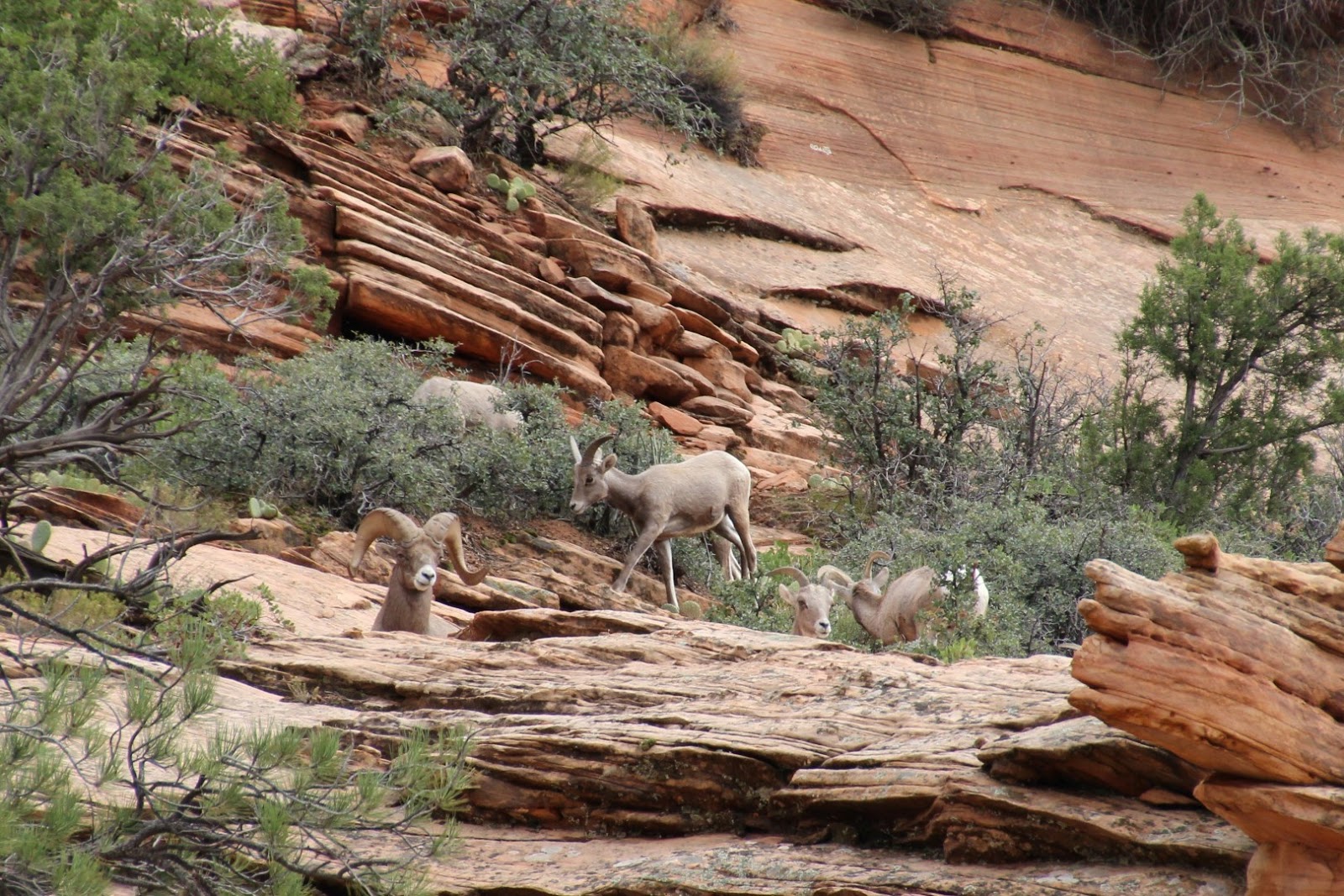
| One very large male Bighorn Sheep and his family in Zion National Park, Utah. |
 |
| Chip wasn't sure what to make of some of the White Tailed Deer we saw. Surprisingly, the deer weren't so easily scared off by him. |
 |
| The cliffs of Zion National Park, Utah. |
 |
| Shonah crossing the river on our hike up part of The Narrows in Zion National Park, Utah. Amazingly Todd was able to encourage Shonah to continue on even though there was a flash flood warning in effect that day. |
 |
| A Tri-Colored Heron hunting in the Virgin River in Zion National Park, Utah. |
 |
| Waterfall near the Emerald Pools in Zion National Park, Utah. |
 |
| Shonah in front of one of the Emerald Pools in Zion National Park, Utah. |
 |
| A view from the North Rim of Grand Canyon National Park, Arizona. The North Rim is much less visited than the more touristy and developed South Rim. |
 |
| Chip and Todd taking a break during one of our hikes along the North Rim of Grand Canyon National Park, Arizona. |
 |
| One of the elusive Kaibab Squirrels in Grand Canyon National Park, Arizona. Kaibab Squirrels only live in the Ponderosa Pine forests. |
 |
| The Colorado River near Page, Arizona as it flows into the Grand Canyon. |
 |
| The Glen Canyon Dam in Page, Arizona created Lake Powell (behind the dam) which is the second-largest artificial lake in the country and extends well into Utah. |
 |
| The Horseshoe Bend of the Colorado River is named for obvious reasons and is located 5 miles downstream from the Glen Canyon Dam near Page, Arizona. |
 |
| Keet Seel or Kiet Siel (Kįtsʼiil), which stands for "broken house" in Navajo, is a well preserved cliff dwelling of the ancient Anasazi people located in a branch of the Tsegi Canyon in the Kayenta region of the Navajo territory. |
 |
| A classic view of Monument Valley from The Navajo Tribal Park in Northern Arizona. |
 |
| Todd and Chip enjoying some time in our dispersed campsite somewhere in the Valley of the Gods, Utah. |
 |
| How many years do you think these rocks have been balancing like this and how many more do you think they will last? |
 |
| One of the fun roads less travelled that we took was the Trail of the Ancients near Blanding, Utah. This portion of the route travels up the face of this cliff using a series of switchback roads. |
 |
| Thankfully, the road was wide enough for our vehicle everywhere and had areas where vehicles from opposite directions could pass. |
 |
| A view of part of the Trail of the Ancients road from the top. |
 |
| A beautiful view over the cliffs and desert near Blanding, Utah. |
 |
| "Cliff Palace" cliff dwelling in Mesa Verde National Park, Colorado. For over 700 years beginning around 550 AD, Ancestral Puebloan people and their descendants lived and flourished in the Four Corners Region of Colorado. |
 |
| They built elaborate stone communities in the sheltered alcoves of canyon walls. In the late 1200's in the span of a generation or two, they left these homes and moved away. |
 |
| Bear Creek Falls along the Million Dollar Highway south of Ouray, Colorado. The original portion of the Million Dollar Highway was a toll road built by Otto Mears in 1883 to connect Ouray and Ironton. This stretch through the gorge is challenging and potentially hazardous to drive; it is characterized by steep cliffs, narrow lanes, and a lack of guardrails; in other words - FUN (unless you are sitting in the passenger seat). |
 |
| As we travelled the higher elevations of Colorado near Ouray on our way toward Colorado Springs, we were treated to our first snow storm of the year. |
 |
| Chip (sporting his new doggles), Shonah, Todd, Todd's great nephew CK, niece Stephanie, great niece Raegan (in backpack) and Stephanie's husband Tony during our hike in the Garden of the Gods in Colorado Springs, Colorado. We ended up visiting them on Halloween and enjoyed our hike and seeing all the kids in the neighborhood dressed up for trick-or-treating. |